
2026-05-16
From Pixels to Parcels: A Practical Guide to GIS Annotation
Geospatial data annotation is the invisible backbone of autonomous vehicles, smart cities, and precision agriculture. Here's how it works — and why it's harder than it looks.
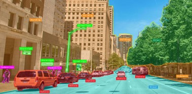
A self-driving car approaches an intersection it has "seen" a thousand times. In a fraction of a second, its perception stack recognises lane boundaries, traffic signals, kerb edges, and a cyclist crossing. None of that recognition is possible without a prior human — or AI-assisted — act of labelling. Someone, at some point, drew a polygon around that kerb. That act is GIS annotation, and it is the invisible backbone of every spatial AI system operating in the world today.
What Is GIS Annotation?
GIS (Geographic Information System) annotation is the process of attaching semantic labels to geospatial data so that machine-learning models can interpret location, geometry, and context. The raw inputs — satellite tiles, aerial imagery, LiDAR point clouds, or BIM models — mean nothing to a model until features are labelled.
Common annotation types include:
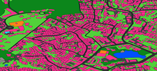
- Building footprint extraction — outlining structures from above for urban planning and insurance models
- Land-use and crop classification — labelling fields, forests, water bodies, and bare soil in satellite imagery
- Cadastral boundary labelling — tracing legal land parcel edges for government and proptech datasets
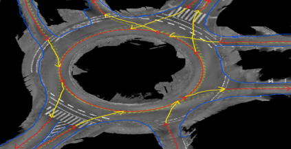
- HD map annotation — marking lane centres, road markings, traffic signs, and barriers for ADAS and autonomous driving
- Point cloud / LiDAR annotation — placing 3D cuboids around vehicles, pedestrians, and infrastructure in depth data
Where GIS Annotation Is Used
Autonomous Vehicles and ADAS
HD maps for self-driving systems are not static road atlases. They encode sub-centimetre lane geometry, traffic sign positions, speed-limit zones, and drivable-surface boundaries — all labelled from LiDAR sweeps and camera footage. Every major autonomous vehicle programme consumes millions of annotated frames per month.
Smart Cities and Digital Twins
Municipalities building digital twin platforms need every building footprint, every utility trench, and every piece of street furniture labelled and georeferenced. The annotated data feeds simulation models used for traffic planning, emergency response, and infrastructure maintenance.
Precision Agriculture and Environmental Monitoring
Crop-type classification from satellite imagery allows agronomists to estimate yield, detect disease early, and plan irrigation at field level. Deforestation monitoring and flood-risk modelling rely on the same underlying annotation pipelines — pixels labelled by class, by change, by severity.
Why GIS Annotation Is Harder Than Image Annotation
Most teams that have run image annotation projects underestimate geospatial work. Here is why:
Coordinate accuracy matters. A bounding box that is 10 pixels off in a product photo is a quality issue. The same error in a cadastral boundary can put a legal parcel line on the wrong side of a fence. Tolerances are measured in centimetres, not pixels.
Topology must be valid. Polygons in a GIS dataset cannot self-intersect, cannot have gaps between adjacent parcels, and must honour shared edges. Standard annotation tools designed for computer vision have no concept of topological integrity — they will happily produce broken geometry that breaks every downstream GIS tool.
Data formats are specialist. Annotators must understand GeoJSON, shapefiles, and coordinate reference systems (CRS). An annotation delivered in the wrong projection is useless, and reprojecting incorrectly corrupts geometry.
Scale is extreme. A single satellite scene covers hundreds of square kilometres. A national cadastral update project involves millions of individual parcels. Throughput and consistency requirements dwarf typical CV annotation projects.
BIM adds a third dimension. Building Information Modelling annotation requires labelling structural elements, MEP (mechanical, electrical, plumbing) systems, and room classifications inside 3D architectural models — a discipline that requires domain knowledge as well as tool proficiency.
How ASPL Approaches Geospatial Annotation
ASPL provides end-to-end geospatial data annotation services for clients in autonomous vehicles, geospatial AI, proptech, AEC, and smart city platforms. The workflow is built around three principles:
AI-assisted pre-labelling. Our Pixeal platform applies AI pre-labelling to satellite imagery, aerial photos, and point cloud data before human annotators review. On typical geospatial tasks this reduces annotator effort by 60–70%, which directly compresses turnaround time and cost without sacrificing accuracy.
Domain QA workflows. Unlike generic annotation vendors, our QA pipeline validates geospatial-specific correctness: coordinate accuracy checks, topology validation, BIM schema compliance, and CRS consistency. Errors that would pass a pixel-level visual review are caught before delivery.
Native GIS and 3D support. Pixeal supports the annotation types that matter for spatial data — polygons, polylines, segmentation masks, 3D cuboids, and BIM element tagging — all with native export to GeoJSON, Shapefile, LAS/LAZ, and IFC formats.
We handle: - HD map annotation for ADAS and autonomous driving - Cadastral boundary and building footprint labelling - Satellite imagery annotation for crop classification and land-use segmentation - Digital twin annotation — building footprints, street furniture, utility networks - BIM annotation for structural elements and MEP systems - Infrastructure asset annotation for government and defence clients
Choosing a Geospatial Annotation Partner
If you are evaluating geospatial annotation services, the questions that matter most are:
- Does the platform validate topology? A vendor that cannot catch self-intersecting polygons will ship broken geodata.
- What QA process exists for coordinate accuracy? Ask for the tolerance spec and how it is enforced.
- Can they handle your data format natively? Avoid projects where your data is converted twice on the way in and twice on the way out.
- What is the pre-labelling story? AI-assisted pre-labelling on satellite imagery is now table-stakes — if a vendor is doing everything manually, their cost and turnaround will not be competitive.
- Do annotators have domain knowledge? Cadastral annotation, BIM annotation, and HD map annotation each require different expertise. Generalist annotators produce generalist errors.
Getting Started
Geospatial annotation projects benefit enormously from a small scoping exercise before full production. A pilot covering one representative tile type — one satellite scene, one point cloud sweep, one BIM model — surfaces format issues, accuracy requirements, and edge cases before they become expensive.
If you are building a geospatial AI dataset and want to talk through scope and approach, get in touch with the ASPL team. We work with teams ranging from early-stage geospatial AI startups to national mapping agencies.
ASPL provides geospatial data annotation services, BIM annotation, HD map annotation, and satellite imagery annotation services from our delivery centres, backed by the Pixeal AI-assisted annotation platform. Learn more about our Geospatial Services.